Maryland is now the second state to offer residents the option of storing their digital driver’s license or state ID card in their Apple Wallet, following Arizona.

Maryland Gov. Larry Hogan has submitted a $101.25 million supplemental budget to the General Assembly to expand the state’s cyber readiness and workforce initiative.

What does technology really cost – and perhaps an even more critical question – how do you fund its acquisition?
The state of Maryland is launching Connect Maryland, a program that will infuse $400 million in broadband investment to address the digital divide, Gov. Larry Hogan announced.
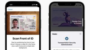
Eight states – Arizona, Connecticut, Georgia, Iowa, Kentucky, Maryland, Oklahoma, and Utah – will offer residents digital driver’s licenses for Apple devices.

The state of Maryland will award $29,472,131 in grant funding to expand broadband internet access for over 12,000 households in 18 counties, Gov. Larry Hogan announced.
Like other states across the country, Maryland needs to reduce the number of COVID-19 infections to flatten the curve. Contact tracing—the process of reaching out to people who tested positive for the virus and alerting people who have been in contact with them—is an essential part of the state’s strategy.
The State of Maryland Department of Human Services (DHS) is making big strides in a two-year campaign to create an AWS-powered technology environment that will integrate the state’s health and human service applications to more effectively deliver services to state residents.


The State of Maryland today announced that the Data Center Energy Efficiency Grant Program (DCEEG) has entered its third cycle. The program, which the state claims is the first of its kind in the United States, provides funding on a competitive basis to “encourage the implementation of cost-effective energy efficiency technologies in data centers throughout the state,” according to the state’s Energy Administration.
Stay Connected

